
Land Degradation
Landslides
The tunnel and gully erosion maps for the Corangamite catchment management region are subsets from the original data presented in the articles on tunnel erosion and gully erosion in the Statewide VRO website, so that the accuracy of information has not been improved.
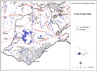 Corangamite Tunnel Erosion | Most tunnelling was located in the northern and southern parts of the region although some may have been destroyed (such as those discussed by Pitt in 1981) whilst new tunnels may have formed elsewhere and are not marked n this map. |
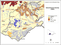 Corangamite Gully Erosion | Similarly, the spatial distribution of gully erosion in the region may have altered since the time the map was constructed. The highest density of gullying was 0.2 – 0.5 km/km2 in patches south-west of Ballarat and east of Timboon whilst a large area of gully erosion < 0.2 km/km2 was found in the northern part of the region where it bore some coincidence with the pattern of tunnelling. A smaller patch of gullying < 0.2 km/km2 was located north-west of Lorne but, generally speaking, gully density is rated as ‘low’ in most of the region. |
Reference
Pitt, A.J. (1981) ‘A study of the land in the catchments of the Otway Range and adjacent plains.’ Soil Conservation Authority of Victoria Technical Communication No. 14. (Government Printer: Melbourne)
Related Links
Land Degradation information on the Statewide VRO website.
© State of Victoria (Agriculture Victoria) 1996 - .

This work, Victorian Resources Online, is licensed under a Creative Commons Attribution 4.0 licence. You are free to re-use the work under that licence, on the condition that you credit the State of Victoria (Agriculture Victoria) as author, indicate if changes were made and comply with the other licence terms.
The licence does not apply to ‘branding’ or some ‘images or photographs’ that may be owned by third parties. We ask you to seek prior approval to use images using the VRO feedback form. Access to higher quality images can also be provided on request.
This page was last updated on .